South Kent School’s first High Altitude Balloon mission marked the culmination of one of the Fall term’s Center for Innovation classes. The students launched and recovered their payload after a three hour flight and a distance of approximately 130 miles .
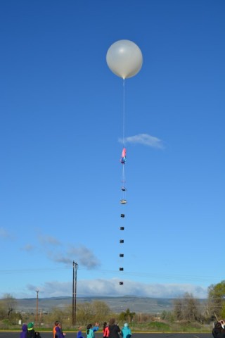
“Cardinal I” was a triangular frame piloted by veteran Mission Commander C. “Red” Bird. The frame carried a payload with several sensors, a GPS tracker, two GoPro Hero 3 HD cameras, a 600 g. weather balloon (5 feet in diameter when inflated with 95 cu. ft. of helium), and a recovery parachute. Prior to the launch, the South Kent students filed an official NOTAM (NOtice To AirMen) with the FAA.
While aloft, Cardinal 1 communicated with its satellite every six minutes. Its location was updated in real time for the team to follow in the mission’s “chase vehicle”. These GPS signals were lost during a blackout period which began at roughly 20,000 feet. GPS tracking resumed once the GPS reestablished contact on descent/reentry. Cardinal 1’s on-board flight computer also recorded temperature, atmospheric pressure, altitude, date and time, ground speed, latitude, longitude, and heading at regular intervals during the flight. Video was recorded on both cameras for the flight’s first 110 minutes until the sub-zero temperatures temporarily “bricked” the GoPros.
The parachute deployed at just under 90,000 feet (about 17 miles or 27 km.), the burst altitude of Cardinal 1’s large weather balloon. This was well into the stratosphere which, at South Kent’s latitude, is between 30,000 and 160,000 feet. The parachute deposited the payload gently into the top of a stately maple tree in Hollis, NH – approximately 130 miles from South Kent School – where it was retrieved with the generous assistance of a local tree company’s bucket truck.
The South Kent students who will be responsible for “Cardinal II” will focus on greater stabilization of the airframe and more effective insulation of the GoPro cameras. Go Cardinals!